|
A publication for those interested in topics relating to above-ground and subsurface utility locating, and Geographic Information System (GIS) and Glo
|
|
A publication for those interested in topics relating to above-ground and subsurface utility locating, and Geographic Information System (GIS) and Global Positioning System (GPS) mapping. Join us on the 3rd Wednesday of every month to explore how cutting edge technology and innovation, combined with a desire to educate and protect the public, will serve you well as a professional in the land use industry. |
 Owner James D. Nadeau, has been a State of Maine Professional Land Surveyor since 1993 and is currently the only PLS in New England that holds the national designation of Certified Floodplain Manager. He has also obtained a North Carolina based Certified Floodplain Surveyor designation, and is a Certified Underground Utility Locator. |
Above And Below (AAB) is a certified and insured utility locating company established in 2009 by James D. Nadeau, owner of Nadeau Land Surveys, a Portland, Maine firm that also specializes in floodplain management, GPS/GIS mapping,and professional land surveying.
Founded on the belief that utility locating and land surveying are symbiotic in their intent to transform the unknown into reliable data, we offer an innovative and unique integration of services, including identification and survey-grade mapping of underground infrastructure to meet the needs of clients of many different industries and professions.
With field equipment such as the Topcon Hyper II GPS, Radiodetection RD8000, MALA Ground Penetrating Radar, Radiodetection C.A.T. 4+, Pipehorn 100, Vivax-Metrotech VM-810, and various models of Schonstedt magnetic locators, we are able to be consultants from feasibility to final as-built plans.
We welcome designers, planners, architects, engineers, excavators, Realtors, code officers, town officials, and anyone else who could benefit from increased knowledge in utility locating and mapping to receive this newsletter. Our goal is to highlight issues that will help move the industry forward by raising awareness about local regulations, best practices, and the benefits of combining accurate utility location with GPS/GIS mapping. Please enjoy and feel free to forward to a friend! |
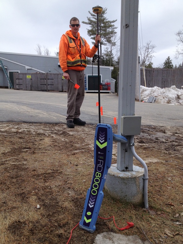 Alex St. Peter comes to us from the Adirondack Mountain region of New York. With his own underground utility locating company there, he served homeowners and excavators by locating underground electrical power, telephone, cable television, fiber optics, water pipes, sanitary sewer and natural gas lines. Alex began his career as a land surveyor and has completed classes in geomatics at Central Connecticut State University. |
Diversified Services
Among our many services, we offer:
▪ Field location of private and public above ground and subsurface utility infrastructure, with or without elevations. Obtaining elevations, best when performed prior to backfilling, will aid greatly in the final as-built process.
▪ Accurate identification for design or excavation purposes.
▪ Loss prevention through diligent research.
▪ Electronic data storage for future use.
Unique Products
Our product is unique because we collect and consolidate data typically gathered from multiple consultants. Among our many products, we offer:
▪ Insured final plans prepared by a State of Maine Professional Land Surveyor.
▪ Using GIS, we can integrate utility data with other GIS data, creating a multi-layered plan in a format that can be efficiently used in different applications, such as municipal as-built approvals.
▪ With the use of a Global Positioning System, coordinate values can be placed on the Maine State Plane Coordinate System in either NGVD29 or NAVD88.
|
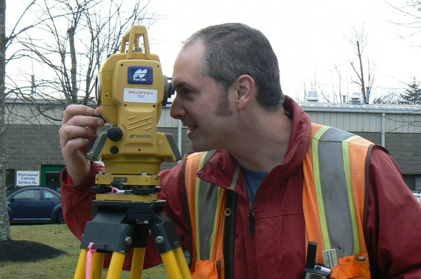 Tom Blake, Professional Land Surveyor, received his Bachelor of Science in Forest Engineering from the University of Maine, and has 20 years of surveying experience. Tom serves as Curator for the New Gloucester, Maine, Historical Society, and is the proud author of “Images of America-New Gloucester”, released September 2009 by Arcadia Publishing. |
Did you know?
The annual cost due to utility damage is in the billions of dollars and one of the leading causes of accidents and disruptions is inaccurate records and locating.
The untimely discovery of an unknown underground utility needing relocation is one of the major causes of delay during construction projects, often causing budget overruns.
Many utilities that once had a known location often have to be found again, especially when excavations cover up or remove the markings. One-call systems and current locating practices are clearly necessary and have contributed to increased public safety. Complimenting those systems with reliable database information, such as GIS and State Plane Coordinates, is a practical approach for long term safety.
Nationwide research has concluded that implementing such mapping technologies is the key to a more unified and efficient industry. Congress even tried to pass a bill (H.R. 4233) called the "Map It Once, Use it Many Times Act" that would add to the National Spatial Data Infrastructure (NSDI), "information on underground infrastructure, including location, type, size, composition, and use of underground structures including tunnels and pipelines." Unfortunately, the bill died and was referred to a committee. Here at AAB, we grasp the important concept of collecting and storing accurate underground utility data for future use. |
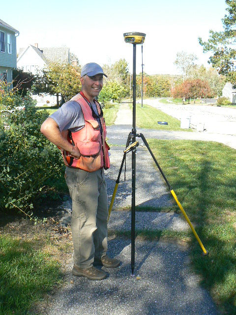 Mark Carpenter, Professional Land Surveyor, has been working in the surveying profession since 2002. He graduated from the University of Maine's Forestry program and completed his surveying courses at Central Maine Community College. He is an active member in the local Narraganset Chapter of the Maine Society of Land Surveyors and currently holds the position of Chapter Secretary. |
Be Aware of Dig Safe's Policies
What is Dig Safe?
Dig Safe® is a not-for-profit clearinghouse that notifies participating utility companies of your plans to dig. In turn, these utility companies (or their contracted locating companies) respond to mark out the location of their underground facilities. Dig Safe is a free service, funded entirely by its member utility companies. (Dig Safe 2013) This service is available for excavation purposes only.
Take Note:
▪ Even with a Dig Safe ticket, public utility companies will not mark on private property. Private utilities need to be located before the start of any construction project to prevent damages and the need to redesign plans.
▪ Dig Safe does not actually locate or mark utilities, nor will they submit a request for public utility companies to do so for design purposes, only for excavations.
▪ A Dig Safe ticket will always be required for excavation, and should only be processed if you intend to excavate within 30 days.
▪ As-built plans prepared by AAB do not replace the requirement of obtaining a Dig Safe ticket prior to excavation. "Information requested from an operator for design purposes shall not be a substitute for the notice of intent to perform excavation." (Dig Safe 2013)
▪ Dig Safe recommends that if you need utilities located for design to contact the member utility companies for maps and records. But remember, these may not be accurate! Utility company plans are often very outdated and do not show utility depths.
|
 Brian Berube is licensed in Maine as a land surveyor-in-training. He obtained both his undergraduate and graduate degrees from the University of Maine and currently holds a B.S. in Forest Operations Science with minors in Surveying Engineering and Forest Products. |
FCC Regulations for RTK GPS Equipment
As land surveyors, we use a variety of GPS equipment for our projects. A recent regulation of the Federal Communications Commission (FCC) now requires that RTK GPS surveying equipment be registered and licensed. This was prompted by complaints of interference with voice communications that use the same radio frequencies as GPS data receivers. (Voice communications have priority over data communications.)
Most RTK GPS equipment operates under set frequencies between 450-470 MHz. The FCC licensing rules will require users to cooperate by taking precautions to minimize interference with voice repeater inputs (455-460 MHz and 465-470 MHz). Penalties will apply to those who do not comply with FCC Rules.
The majority of complaints of interference occurred with the following community voice repeater input frequencies: 469.500, 469.550, 469.600, 469.625, 469.650, 469.700, 469.725, and 469.750 MHz.
Many GPS companies have been working closely with the FCC to address these interference issues and want to help customers understand compliance. Contact your GPS provider for more information. |
Thank You
We would like to thank you for your interest in Above And Below. We welcome your feedback as we launch this new publication, and hope that you find it both interesting and informative. Now that we have introduced ourselves, check out what is in store for next month!
In April's Issue of Above And Below
▪ Integrating Technologies: How It Can Save You On Your Next Project
▪ Resources: Sites and Documents to Have On Hand
▪ In the News: Articles About Utility Locating and Mapping
|
Want to learn more about AAB Utility Locating and Nadeau Land Surveys?
Visit our website.
Have a specific question?
Email Jim Nadeau, at jim@aabutilitylocating.com.
Ready to request our services?
Fill out our web form.
Interested in learning about flood zones, land surveying, real estate, and local history?
Check out our other monthly e-newsletter, Welcome to the Flood Zone, and subscribe using the form provided. |
|
|
|
|

